Flood Zone
View FULL Goshen Flood Resilience Plan here
Goshen outlines flood plan to reduce future risk
City staff shared details of Goshen’s long-term flood zone adaptation strategy during a March 5, 2024, public event at the Elkhart County Community Center.
The event was part of the Elkhart County Soil and Water Conservation District’s Pay Dirt Conference, focused on regional water and soil health.
Goshen’s Flood Resilience Plan, adopted in 2022, outlines strategies to reduce risk and protect flood-prone neighborhoods.
The city developed the plan with help from the American Planning Association and Indiana University’s Environmental Resilience Institute.
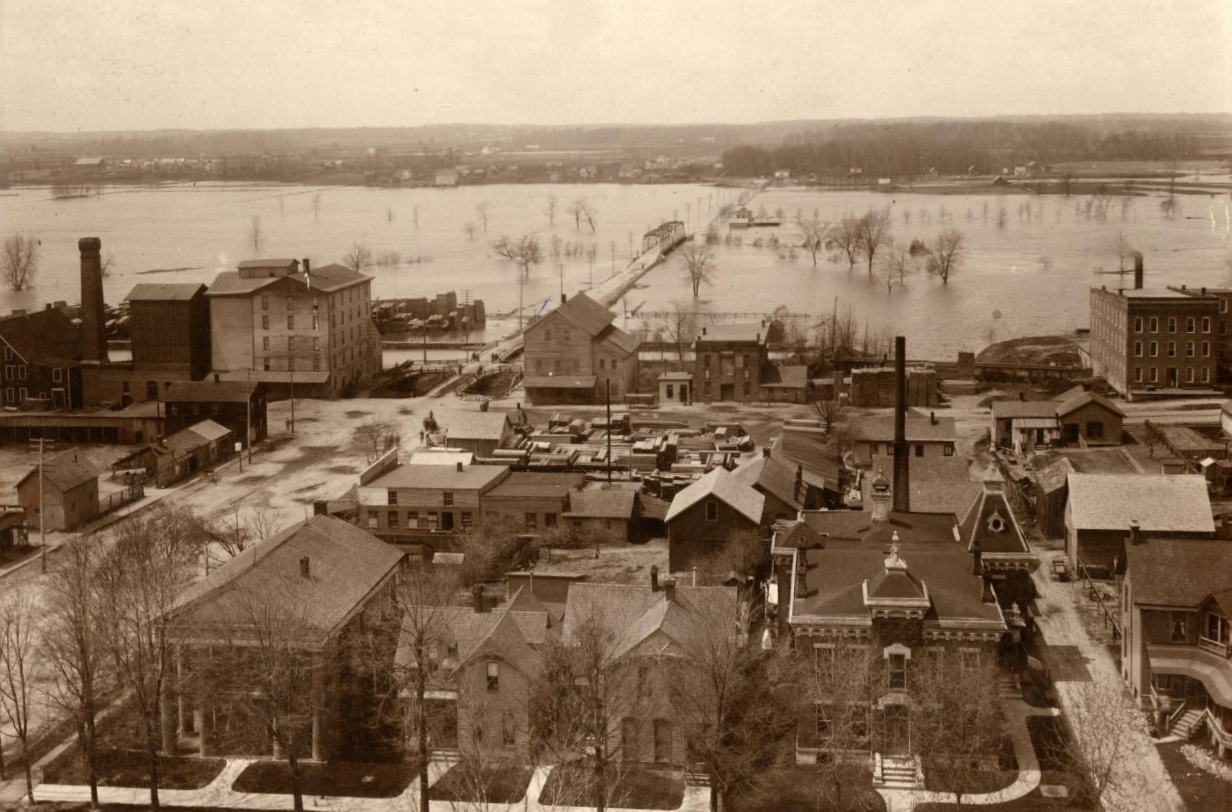
Plan follows record-setting flood in 2018
The effort began after the 2018 flood, which damaged 300 properties and caused $20 million in losses across the city.
In response, Goshen hired Christopher Burke Engineering to help draft a plan grounded in flood modeling, risk data, and public input.
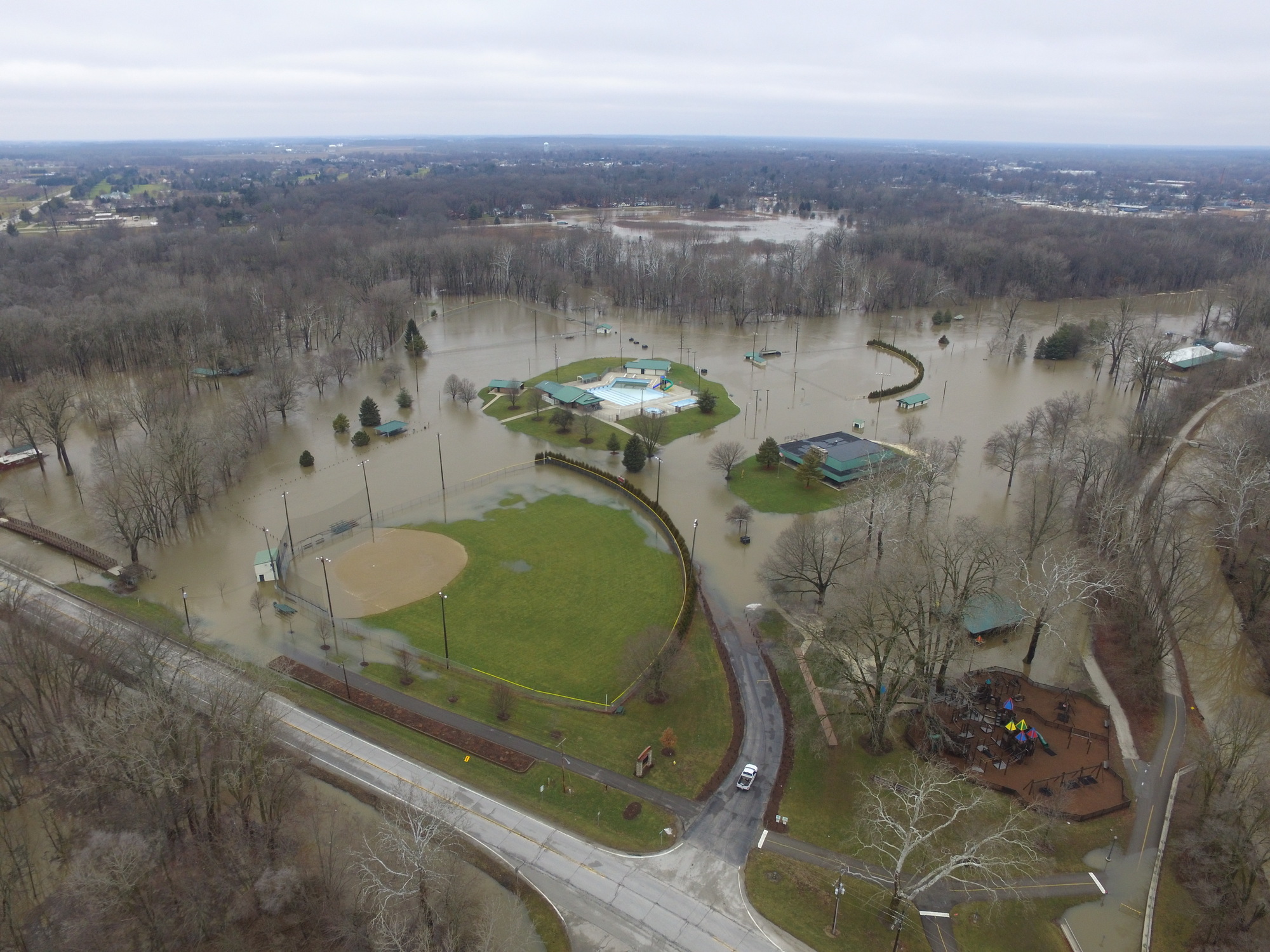
Flooded Shanklin Park during the February 2018 Flood (photo credit Andrew Kauffman)
Climate change adds urgency to local flood zone planning
Climate projections show Goshen—and much of the Midwest—will experience more frequent and intense storms in coming decades. Even with engineered protections like levees or elevated buildings, flood losses are increasing nationwide.
The plan recognizes that Goshen cannot fully prevent extreme rainfall, but it can adapt through long-term strategies that reduce vulnerability and improve response.
Flood resilience, as defined in the plan, means preparing for, absorbing, recovering from, and adapting to future flood events.
A two-pronged strategy for resilience
Goshen’s approach combines two main strategies. First, it uses planning tools to guide growth and infrastructure away from high-risk areas. Second, it introduces projects to protect people and assets already in vulnerable zones.
This dual strategy helps reduce long-term exposure while addressing today’s threats.
The plan encourages local leaders and residents to rethink how the city grows in order to avoid repeating past flood losses.
Citywide and area-based strategies
The plan outlines citywide recommendations, including updates to the comprehensive plan, zoning ordinance, stormwater ordinance, and city code. It also calls for improved risk communication and evaluating stormwater utility funding for future capital projects.
Flood strategies are further tailored to six geographic planning areas, each defined by its role in the larger river system:
- River corridor impact area (floodway and erosion hazard zones)
- Undeveloped high hazard/flood storage areas
- Moderate flood hazard areas (500-year flood zones)
- Vulnerable developed areas already inside the floodplain
- Safer areas outside the floodplain but within city planning boundaries
- Entire watershed or drainage basin
Actions include protecting open spaces, requiring compensatory flood storage, floodproofing buildings, relocating structures, and bringing noncompliant uses into alignment with updated codes.
The plan guides future growth to safer areas and promotes regional partnerships to slow, spread, and absorb stormwater before it causes damage downstream.
Tools help residents understand risks and prepare for flooding
The City of Goshen’s Stormwater Department created the Know the Risks Project to increase local understanding of flood risk and improve preparedness.
The project includes interactive story maps and tools designed to support a more adaptive, resilient community in the face of climate change.
Story maps explore risk, history, and real-time data
The Understanding Flood Risk in Goshen story map uses FEMA data to explain how flood risks are assessed across Goshen. The map offers a guided tour of available tools, or residents can explore the data directly.
The Learning from the Past story map includes images and accounts from past floods, including photos from the 2018 event submitted by local residents and the Goshen Historical Society.
The Goshen USGS River Gauge map explains how to interpret river levels at the Indiana Avenue Bridge and what they mean for nearby homes and businesses.
Assessment connects flooding to climate trends
The city also partnered with the Great Lakes Integrated Sciences and Assessments to produce the Climate Change Vulnerability Assessment for Stormwater.
The study reviewed infrastructure, identified vulnerable sites, and developed a matrix of priority areas for further action and monitoring.
Direct questions about the assessment to the Stormwater Department at stormwater@goshencity.com.
Additional tools for flood awareness and cleanup
The Advanced Hydrologic Prediction Service provides river height forecasts from the National Weather Service. Residents can use it with the USGS River Gauge story map to anticipate localized flooding.
The Flood Factor tool estimates flood risk by address and includes projected damage costs and recommended mitigation steps. In many cases, city staff found its models reflect the 2018 flood more accurately than FEMA maps.
For flood cleanup, the EPA Flooded Homes Cleanup Guidance site offers instructions for returning home safely, doing repairs, and protecting health after a disaster.
Survey
Please share your thoughts on the drafted plan by taking the survey below. If you have multiple questions or areas of concern, please submit another survey.